IMAGES TAKEN NEAR TO
Torridge Road, PLYMOUTH, PL7 2DG
Introduction
This page details the photographs taken nearby to Torridge Road, PL7 2DG by members of the Geograph project.
The Geograph project started in 2005 with the aim of publishing, organising and preserving representative images for every square kilometre of Great Britain, Ireland and the Isle of Man.

There are currently over 7.5m images from over14,400 individuals and you can help contribute to the project by visiting https://www.geograph.org.uk
Image Map
Images are licensed for reuse under creativecommons.org/licenses/by-sa/2.0
Notes
- Clicking on the map will re-center to the selected point.
- The higher the marker number, the further away the image location is from the centre of the postcode.
Image Listing (15 Images Found)
Images are licensed for reuse under creativecommons.org/licenses/by-sa/2.0
Image
Details
Distance
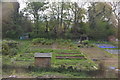
2

Horse chestnut flower, Plympton
By the path on the north side of Glen Road, the B3416.
Image: © Derek Harper
Taken: 5 Jul 2013
0.18 miles
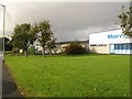
3

Newnham Industrial Estate
A series of industrial buildings and trading estates line Bell Close.
Image: © Derek Harper
Taken: 5 Nov 2009
0.19 miles
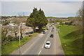
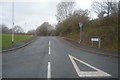
4
Roundabout on Strode Road (B3417)
Junction with Glen Road.
Image: © JThomas
Taken: 8 Nov 2014
0.21 miles
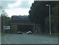
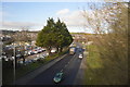
6
Newnham Industrial Estate
On the right are the premises of Morris Engineering Ltd, a precision engineering company.
Image: © Derek Harper
Taken: 5 Nov 2009
0.22 miles
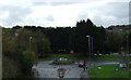
8
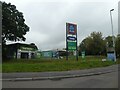
Car wash and Aldi sign, Strode Road, Plympton
Image: © David Smith
Taken: 22 Sep 2020
0.23 miles