IMAGES TAKEN NEAR TO
Moorland Road, PLYMOUTH, PL7 2BJ
Introduction
This page details the photographs taken nearby to Moorland Road, PL7 2BJ by members of the Geograph project.
The Geograph project started in 2005 with the aim of publishing, organising and preserving representative images for every square kilometre of Great Britain, Ireland and the Isle of Man.

There are currently over 7.5m images from over14,400 individuals and you can help contribute to the project by visiting https://www.geograph.org.uk
Image Map
Images are licensed for reuse under creativecommons.org/licenses/by-sa/2.0
Notes
- Clicking on the map will re-center to the selected point.
- The higher the marker number, the further away the image location is from the centre of the postcode.
Image Listing (48 Images Found)
Images are licensed for reuse under creativecommons.org/licenses/by-sa/2.0
Image
Details
Distance
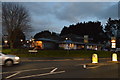
2
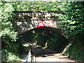
George Lane, Plympton
Whilst a large part of Plympton and Chaddlewood have been the subject of housing and industrial growth since the mid-1960s, the occasional reminder can be found of the origin 'stannary town'- this is the point where the GWR railway crosses George Lane, which used to run from the Ridgeway, through to the Cornwood/Sparkwell road.
Image: © Gwyn Jones
Taken: 15 Oct 2005
0.06 miles
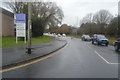
5
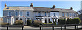
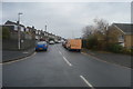
Regent Terrace or Villas
This terrace of properties features in a post card of around 1900 when the road name of Moorlane had some more significance than it has today. When constructed the residents would have had an uninterrupted view across to the edge of Dartmoor. Now the open grass land on the west side of Moorland Road has the Ridgeway Comprehensive School built over it which obscures the moorland view for those in Regent Terrace.
Regent Terrace was built by the successful brewer Samuel Vosper who had a brewery in Durnford Street, East Stonehouse in Plymouth. Sadly there is no reference in or around the terrace of houses to indicate its original name. Image
Image: © Colin Vosper
Taken: 10 Mar 2010
0.11 miles