IMAGES TAKEN NEAR TO
Aycliffe Gardens, PLYMOUTH, PL7 1YN
Introduction
This page details the photographs taken nearby to Aycliffe Gardens, PL7 1YN by members of the Geograph project.
The Geograph project started in 2005 with the aim of publishing, organising and preserving representative images for every square kilometre of Great Britain, Ireland and the Isle of Man.

There are currently over 7.5m images from over14,400 individuals and you can help contribute to the project by visiting https://www.geograph.org.uk
Image Map (Loading...)


Getting Data...Please wait
Leaflet Map data © OpenStreetMap
Images are licensed for reuse under creativecommons.org/licenses/by-sa/2.0
Notes
- Clicking on the map will re-center to the selected point.
- The higher the marker number, the further away the image location is from the centre of the postcode.
Image Listing (13 Images Found)
Images are licensed for reuse under creativecommons.org/licenses/by-sa/2.0
Image
Details
Distance
2

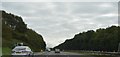
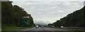
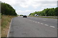
Ermington : Devon Expressway A38
Looking along the Devon Expressway A38.
Image: © Lewis Clarke
Taken: 3 Dec 2019
0.14 miles
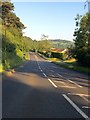
4
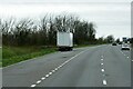
Layby on the A38 near to Plympton St Maurice
Image: © David Dixon
Taken: 11 Apr 2022
0.17 miles
5
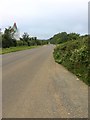
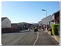
Minor road
Soon to be out of use, when the new road from Sherford comes into use. Maybe just some local traffic using it. On the left is the large sign advertising the Sherford housing being built. Really a new town on the edge of Plymouth, eventually having a school, shops, etc.
Image: © jeff collins
Taken: 18 Jul 2020
0.18 miles
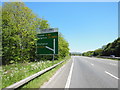
7
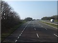
A38 Dual carriageway
West bound just passed the Plympton slip road.
Image: © jeff collins
Taken: 27 Jun 2009
0.21 miles