IMAGES TAKEN NEAR TO
Drunken Bridge Hill, PLYMOUTH, PL7 1UG
Introduction
This page details the photographs taken nearby to Drunken Bridge Hill, PL7 1UG by members of the Geograph project.
The Geograph project started in 2005 with the aim of publishing, organising and preserving representative images for every square kilometre of Great Britain, Ireland and the Isle of Man.

There are currently over 7.5m images from over14,400 individuals and you can help contribute to the project by visiting https://www.geograph.org.uk
Image Map
Images are licensed for reuse under creativecommons.org/licenses/by-sa/2.0
Notes
- Clicking on the map will re-center to the selected point.
- The higher the marker number, the further away the image location is from the centre of the postcode.
Image Listing (13 Images Found)
Images are licensed for reuse under creativecommons.org/licenses/by-sa/2.0
Image
Details
Distance
1
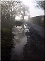
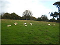
Puddle, Drunken Bridge Hill
An oak is reflected in this puddle close to the reservoir on Drunken Bridge Hill.
Image: © Derek Harper
Taken: 10 Dec 2009
0.12 miles
2
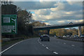
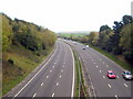
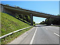
Plympton : Devon Expressway A38
Heading into Plymouth on the Devon Expressway A38.
Image: © Lewis Clarke
Taken: 3 Dec 2019
0.15 miles
4
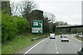
Devon Expressway approaching Marsh Mills
Image: © David Dixon
Taken: 11 Apr 2022
0.16 miles
5
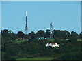
Television and Relay Masts, Hardwick Hill
Upon the skyline, the television and relay masts situated on Hardwick Hill can be seen, as viewed looking north from Elburton Playing Fields, as they tower over "The Gables" residential home (right foreground).
Image: © Gwyn Jones
Taken: 4 Oct 2005
0.16 miles
6
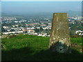
Dorsmouth Rock Trig. Pillar
Standing on the hillside to the south of Plympton, this view from the pillar has Mudge Way to the centre foreground (cream and terracota brick row), with Newnham valley to centre left distant.
Image: © Gwyn Jones
Taken: 15 Oct 2005
0.16 miles
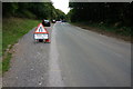
8
The A38 by Hardwick Farm
The main road from Plymouth to the rest of the world.
Image: © Rod Allday
Taken: 24 Oct 2009
0.19 miles
10
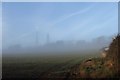
Television Relay Station near Plympton
The twin masts of the TV relay station beside Hardwick Wood are partly hidden in mist. Seen from Drunken Bridge Hill.
Image: © Derek Harper
Taken: 10 Dec 2009
0.21 miles