IMAGES TAKEN NEAR TO
Underlane, PLYMOUTH, PL7 1QZ
Introduction
This page details the photographs taken nearby to Underlane, PL7 1QZ by members of the Geograph project.
The Geograph project started in 2005 with the aim of publishing, organising and preserving representative images for every square kilometre of Great Britain, Ireland and the Isle of Man.

There are currently over 7.5m images from over14,400 individuals and you can help contribute to the project by visiting https://www.geograph.org.uk
Image Map
Images are licensed for reuse under creativecommons.org/licenses/by-sa/2.0
Notes
- Clicking on the map will re-center to the selected point.
- The higher the marker number, the further away the image location is from the centre of the postcode.
Image Listing (6 Images Found)
Images are licensed for reuse under creativecommons.org/licenses/by-sa/2.0
Image
Details
Distance
1
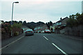
In Plympton
Houses in Merafield Drive.
Image: © Robert Ashby
Taken: 24 Aug 2014
0.12 miles
2
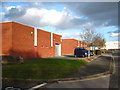
Industrial units in Marshall Road
Part of Cot Hill Industrial Estate.
Image: © Rod Allday
Taken: 24 Oct 2009
0.19 miles
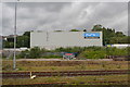
5
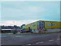
Marsh Mills
Business park at Marsh Mills
Image: © Robert Ashby
Taken: 24 Aug 2014
0.24 miles
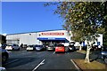
6
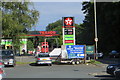
The B3416
Petrol station near Marsh Mills.
Image: © Robert Ashby
Taken: 7 Aug 2015
0.25 miles