IMAGES TAKEN NEAR TO
Hill Close, PLYMOUTH, PL7 1QG
Introduction
This page details the photographs taken nearby to Hill Close, PL7 1QG by members of the Geograph project.
The Geograph project started in 2005 with the aim of publishing, organising and preserving representative images for every square kilometre of Great Britain, Ireland and the Isle of Man.

There are currently over 7.5m images from over14,400 individuals and you can help contribute to the project by visiting https://www.geograph.org.uk
Image Map (39 Images)


Getting Data...Please wait
Leaflet Map data © OpenStreetMap
Images are licensed for reuse under creativecommons.org/licenses/by-sa/2.0
Notes
- Clicking on the map will re-center to the selected point.
- The higher the marker number, the further away the image location is from the centre of the postcode.
Image Listing (39 Images Found)
Images are licensed for reuse under creativecommons.org/licenses/by-sa/2.0
Image
Details
Distance
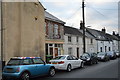
4
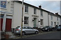
114, Underwood Rd
Grade II listed. http://www.britishlistedbuildings.co.uk/101386482-114-and-114a-underwood-road-plympton-erle-ward
Image: © N Chadwick
Taken: 3 Dec 2016
0.05 miles
6
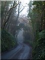
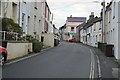
Drunken Bridge Hill
A gloomy climb on a misty morning, on the west side of Plympton.
Image: © Derek Harper
Taken: 10 Dec 2009
0.08 miles
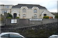
10
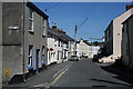
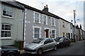
Underwood Road
Just up the hillside from St Mary's Church the name is descriptive as the road is below the steep hill topped with Hardwick Wood.
Image: © Tony Atkin
Taken: 8 Jun 2008
0.09 miles