IMAGES TAKEN NEAR TO
Woollcombe Avenue, PLYMOUTH, PL7 1LA
Introduction
This page details the photographs taken nearby to Woollcombe Avenue, PL7 1LA by members of the Geograph project.
The Geograph project started in 2005 with the aim of publishing, organising and preserving representative images for every square kilometre of Great Britain, Ireland and the Isle of Man.

There are currently over 7.5m images from over14,400 individuals and you can help contribute to the project by visiting https://www.geograph.org.uk
Image Map (Loading...)


Getting Data...Please wait
Leaflet Map data © OpenStreetMap
Images are licensed for reuse under creativecommons.org/licenses/by-sa/2.0
Notes
- Clicking on the map will re-center to the selected point.
- The higher the marker number, the further away the image location is from the centre of the postcode.
Image Listing (102 Images Found)
Images are licensed for reuse under creativecommons.org/licenses/by-sa/2.0
Image
Details
Distance
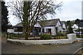
1
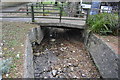
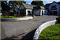
Treby Gardens, Plympton St Maurice, Devon
A couple of garages (perhaps) being built on an unused piece of land between two houses at the junction of Woollcombe Avenue and Treby Gardens.
Image: © David Hallam-Jones
Taken: 19 Aug 2018
0.02 miles
2
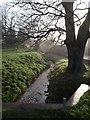
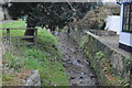
Long Brook
The brook approaches the camera at St Maurice Road in Plympton.
Image: © Derek Harper
Taken: 10 Dec 2009
0.03 miles
3
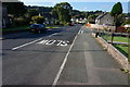
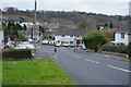
St Maurice Road, Plympton St Maurice
Looking South Southwest.
Image: © jeff collins
Taken: 10 Sep 2014
0.04 miles
7
The Brook Inn, Plympton St Maurice
The inn is on Longbrook Street.
Image: © jeff collins
Taken: 10 Sep 2014
0.11 miles
9
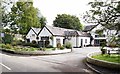
Brook Inn, Plympton St Maurice, Devonshire
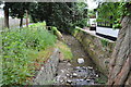
Plympton St Maurice lies in a shallow valley flanked by two ridges. The ridge to the north is the ancient Ridgeway route into Plymouth whilst the high ridge to the south of the village is known as Ridge Lane. The southern ridge carries the A38 dual carriageway. The main water course is the Long Brook which flows east to west through the southern part of the conservation area and here it passes immediately behind the hanging pub sign of this combined restaurant and pub complex. This establishment was originally part of a farm but in 1976 it was converted for its present use. The tallest building, behind the parked car, was formerly a barn whilst some of the single storey rooms were added on.
Image: © David Hallam-Jones
Taken: 29 Aug 2019
0.11 miles