IMAGES TAKEN NEAR TO
Hele Gardens, PLYMOUTH, PL7 1JZ
Introduction
This page details the photographs taken nearby to Hele Gardens, PL7 1JZ by members of the Geograph project.
The Geograph project started in 2005 with the aim of publishing, organising and preserving representative images for every square kilometre of Great Britain, Ireland and the Isle of Man.

There are currently over 7.5m images from over14,400 individuals and you can help contribute to the project by visiting https://www.geograph.org.uk
Image Map (Loading...)


Getting Data...Please wait
Leaflet Map data © OpenStreetMap
Images are licensed for reuse under creativecommons.org/licenses/by-sa/2.0
Notes
- Clicking on the map will re-center to the selected point.
- The higher the marker number, the further away the image location is from the centre of the postcode.
Image Listing (19 Images Found)
Images are licensed for reuse under creativecommons.org/licenses/by-sa/2.0
Image
Details
Distance
1
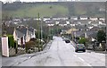
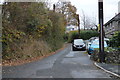
Yeoman's Way, Plympton
Looking towards the steep ridge which marks the southern boundary of Plympton.
Image: © Tony Atkin
Taken: 8 Jan 2006
0.02 miles
2
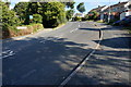
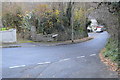
Cherry Tree Lane, Plympton St Maurice
Looking Southwest.
Image: © jeff collins
Taken: 10 Sep 2014
0.09 miles
3
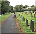
Longcause Cemetery, Plympton St Maurice, Devonshire
A short section of Cherrytree Lane (i.e. in the distance and to the left) allows for vehicular access to this cemetery. To the right however, the lane is a footpath running parallel with Yeomans Way, a residential road. Prior to the 1940s this site and much of the surrounding area was arable farmland, but around that time the land was sold to the local Council to allow for the building of "council houses", with a proviso that this plot was set aside for the creation of a non-conformist cemetery.
Image: © David Hallam-Jones
Taken: 28 Aug 2019
0.10 miles
4
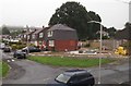
Treby Gardens, Plympton St Maurice, Devon
A couple of garages (perhaps) being built on an unused piece of land between two houses at the junction of Woollcombe Avenue and Treby Gardens.
Image: © David Hallam-Jones
Taken: 19 Aug 2018
0.12 miles
6
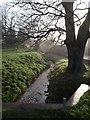
Long Brook
The brook approaches the camera at St Maurice Road in Plympton.
Image: © Derek Harper
Taken: 10 Dec 2009
0.16 miles
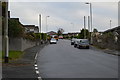
8
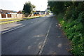
St Maurice Road, Plympton St Maurice
Looking South Southwest.
Image: © jeff collins
Taken: 10 Sep 2014
0.17 miles
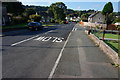
10
Wolverwood Lane, Plympton St Maurice
Looking East Southeast.
Image: © jeff collins
Taken: 10 Sep 2014
0.18 miles