IMAGES TAKEN NEAR TO
Osmand Gardens, PLYMOUTH, PL7 1AA
Introduction
This page details the photographs taken nearby to Osmand Gardens, PL7 1AA by members of the Geograph project.
The Geograph project started in 2005 with the aim of publishing, organising and preserving representative images for every square kilometre of Great Britain, Ireland and the Isle of Man.

There are currently over 7.5m images from over14,400 individuals and you can help contribute to the project by visiting https://www.geograph.org.uk
Image Map
Images are licensed for reuse under creativecommons.org/licenses/by-sa/2.0
Notes
- Clicking on the map will re-center to the selected point.
- The higher the marker number, the further away the image location is from the centre of the postcode.
Image Listing (65 Images Found)
Images are licensed for reuse under creativecommons.org/licenses/by-sa/2.0
Image
Details
Distance

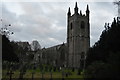
3

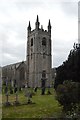
Graveyard, Church of St Mary the Blessed Virgin
Image: © N Chadwick
Taken: 3 Dec 2016
0.04 miles
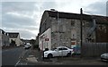

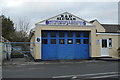
10

Plympton old fire station
Plympton old fire station, Market Road, Plympton, Devon is now used as a vehicle repair garage.
Image: © Kevin Hale
Taken: 8 Oct 2006
0.06 miles