IMAGES TAKEN NEAR TO
Cressbrook Walk, PLYMOUTH, PL6 8RZ
Introduction
This page details the photographs taken nearby to Cressbrook Walk, PL6 8RZ by members of the Geograph project.
The Geograph project started in 2005 with the aim of publishing, organising and preserving representative images for every square kilometre of Great Britain, Ireland and the Isle of Man.

There are currently over 7.5m images from over14,400 individuals and you can help contribute to the project by visiting https://www.geograph.org.uk
Image Map
Images are licensed for reuse under creativecommons.org/licenses/by-sa/2.0
Notes
- Clicking on the map will re-center to the selected point.
- The higher the marker number, the further away the image location is from the centre of the postcode.
Image Listing (19 Images Found)
Images are licensed for reuse under creativecommons.org/licenses/by-sa/2.0
Image
Details
Distance
8
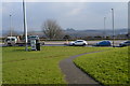
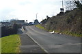
Junction, Estover
Colwill Road (left) meets Weir Road (right); beyond the junction, Colwill Road becomes a cul-de-sac.
Image: © Derek Harper
Taken: 1 Nov 2011
0.19 miles
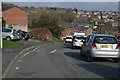
9
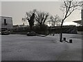
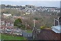
Wintery showers near Asda
Wintery weather in the courtyard near Asda
Image: © Charli
Taken: 31 Dec 2020
0.21 miles
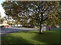
10
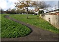
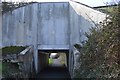
Path, Novorossisk Road, Estover
By the underpass connecting Leypark Walk to Colwill Way beneath the B3432.
Image: © Derek Harper
Taken: 1 Nov 2011
0.22 miles