IMAGES TAKEN NEAR TO
Walkhampton Walk, PLYMOUTH, PL6 8RA
Introduction
This page details the photographs taken nearby to Walkhampton Walk, PL6 8RA by members of the Geograph project.
The Geograph project started in 2005 with the aim of publishing, organising and preserving representative images for every square kilometre of Great Britain, Ireland and the Isle of Man.

There are currently over 7.5m images from over14,400 individuals and you can help contribute to the project by visiting https://www.geograph.org.uk
Image Map
Images are licensed for reuse under creativecommons.org/licenses/by-sa/2.0
Notes
- Clicking on the map will re-center to the selected point.
- The higher the marker number, the further away the image location is from the centre of the postcode.
Image Listing (17 Images Found)
Images are licensed for reuse under creativecommons.org/licenses/by-sa/2.0
Image
Details
Distance
6
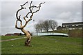
Dead Tree and Footbridge
The footbridge crosses the main road separating the Estover and Leigham housing estates. There is plenty of grass and open space around here but it is covered in litter. This seems to be a land which nobody cares for.
Image: © Tony Atkin
Taken: 12 Feb 2006
0.19 miles
8
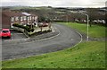
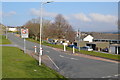
Bradfield Close, Leigham
A different part of the close from Image, from a bank beside Bampton Road. Behind is the Plym valley.
Image: © Derek Harper
Taken: 14 Feb 2015
0.19 miles