IMAGES TAKEN NEAR TO
Delgany Villas, PLYMOUTH, PL6 8AG
Introduction
This page details the photographs taken nearby to Delgany Villas, PL6 8AG by members of the Geograph project.
The Geograph project started in 2005 with the aim of publishing, organising and preserving representative images for every square kilometre of Great Britain, Ireland and the Isle of Man.

There are currently over 7.5m images from over14,400 individuals and you can help contribute to the project by visiting https://www.geograph.org.uk
Image Map
Images are licensed for reuse under creativecommons.org/licenses/by-sa/2.0
Notes
- Clicking on the map will re-center to the selected point.
- The higher the marker number, the further away the image location is from the centre of the postcode.
Image Listing (40 Images Found)
Images are licensed for reuse under creativecommons.org/licenses/by-sa/2.0
Image
Details
Distance
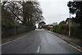

10
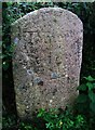
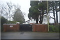
Old Boundary Markers on Tavistock Road, Plymouth
Parish Boundary Marker on the northeast side of the junction of the A386 Tavistock Road and Plymbridge Lane in Plymouth. It is inscribed Tamerton / Foliott. Formerly on the boundary of Tamerton Foliot and Egg Buckland parishes, it is now entirely within Plymouth.
Milestone Society National ID: DV_PLTV12pb
Image: © T Jenkinson
Taken: 8 Nov 2011
0.15 miles