IMAGES TAKEN NEAR TO
Glenholt Park, PLYMOUTH, PL6 7LR
Introduction
This page details the photographs taken nearby to PL6 7LR by members of the Geograph project.
The Geograph project started in 2005 with the aim of publishing, organising and preserving representative images for every square kilometre of Great Britain, Ireland and the Isle of Man.

There are currently over 7.5m images from over14,400 individuals and you can help contribute to the project by visiting https://www.geograph.org.uk
Image Map
Images are licensed for reuse under creativecommons.org/licenses/by-sa/2.0
Notes
- Clicking on the map will re-center to the selected point.
- The higher the marker number, the further away the image location is from the centre of the postcode.
Image Listing (13 Images Found)
Images are licensed for reuse under creativecommons.org/licenses/by-sa/2.0
Image
Details
Distance
1
Deer near Plymouth Airport
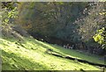
This is rather odd. At the edge of a patch of lush grass and a tangled wood, an environment that belongs on the fringes of Dartmoor, deer stare in amazement as I emerge from the trees. They are within 50 metres of industrial units, and 200 metres of the perimeter fence of the airport. Large numbers graze in a nearby field nearer the runway. So the environs of Plymouth push into wild Devon, which won't go away.
Image: © Derek Harper
Taken: 1 Nov 2011
0.09 miles
2
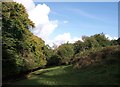
Woodland edge below Darklake View
A reverse view of Image; the deer have left. The business units on Darklake View are just up the hill to the right.
Image: © Derek Harper
Taken: 1 Nov 2011
0.10 miles
3
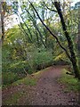
Trackway, Common Wood
I think this must be the former Plymouth and Dartmoor Railway / Lee Moor Tramway, crossing a side valley below Glenholt Park on a curving embankment, as part of a very circuitous route compared to the railway with its viaducts.
Image: © Derek Harper
Taken: 1 Nov 2011
0.11 miles
4
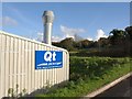
Industrial unit, Darklake View
Qt specialise in offroad vehicles. This is one of a number of new units along Darklake View, a northern extension of Estover Industrial Estate.
Image: © Derek Harper
Taken: 1 Nov 2011
0.14 miles
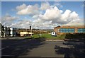
5
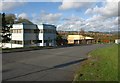
Darklake View
A northern extension of the Estover Industrial Estate, seen from its junction with the B3432 Plymbridge Road. You certainly get good views working here. The two-storey unit on the left is Harscombe House.
Image: © Derek Harper
Taken: 1 Nov 2011
0.16 miles
6
Darklake View
One of the business units on this northern extension of the Estover Industrial Estate, seen from the same spot as Image - in fact, the one seen in Image, with the wooded valley behind it where Image was taken, a few metres beyond, and housing estates on the northeast fringe of Plymouth beyond.
Image: © Derek Harper
Taken: 1 Nov 2011
0.16 miles
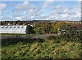
7
Field beside Darklake View
It seems unlikely that this triangular area of grass, the southern corner of a pasture, will remain for long, as most of the rest of the road has been taken up by business units like the one on the left, which is shared by several firms. The view is across the Plym valley to the village of Shaugh Prior on the western fringe of Dartmoor. The estate of Glenholt Park is on the left.
Image: © Derek Harper
Taken: 1 Nov 2011
0.17 miles
8
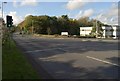
Junction on the B3432
The junction from which Image was taken, looking down Darklake View, the industrial estate road on the right.
Image: © Derek Harper
Taken: 1 Nov 2011
0.18 miles
9
Darklake View
Image: © Derek Harper
Taken: 1 Nov 2011
0.18 miles
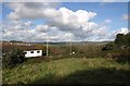
10
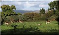
Deer, Estover
Seen from a gateway by the B3432, and grazing unconcerned within 200 metres of an airport runway. Behind the trees in the background is Image, which gives the deer a link to the woodlands of the Plym valley. Dartmoor is in the distance.
Image: © Derek Harper
Taken: 1 Nov 2011
0.21 miles