IMAGES TAKEN NEAR TO
Glenholt Road, PLYMOUTH, PL6 7JA
Introduction
This page details the photographs taken nearby to Glenholt Road, PL6 7JA by members of the Geograph project.
The Geograph project started in 2005 with the aim of publishing, organising and preserving representative images for every square kilometre of Great Britain, Ireland and the Isle of Man.

There are currently over 7.5m images from over14,400 individuals and you can help contribute to the project by visiting https://www.geograph.org.uk
Image Map
Images are licensed for reuse under creativecommons.org/licenses/by-sa/2.0
Notes
- Clicking on the map will re-center to the selected point.
- The higher the marker number, the further away the image location is from the centre of the postcode.
Image Listing (13 Images Found)
Images are licensed for reuse under creativecommons.org/licenses/by-sa/2.0
Image
Details
Distance
1
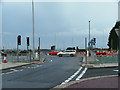
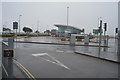
Junction Plymbridge Road - A386 Tavistock Road, Plymouth
A busy junction, recently the subject of road movement, widening and improvement to benefit both commuters and (airport) runway extension. This view of the 'new' junction, as seen looking west from Plymbridge Road.
Image: © Gwyn Jones
Taken: 27 Nov 2005
0.14 miles
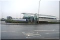
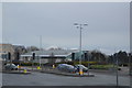
3
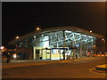
Terminus building at Roborough Park & Ride
Image: © Rod Allday
Taken: 2 Jul 2009
0.20 miles
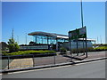
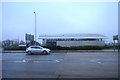
4
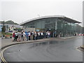
Roborough Park & Ride
Passengers queuing for transport to Home Park for the Rod Stewart concert.
Image: © Rod Allday
Taken: 2 Jul 2009
0.21 miles