IMAGES TAKEN NEAR TO
Moorland View, PLYMOUTH, PL6 6AN
Introduction
This page details the photographs taken nearby to Moorland View, PL6 6AN by members of the Geograph project.
The Geograph project started in 2005 with the aim of publishing, organising and preserving representative images for every square kilometre of Great Britain, Ireland and the Isle of Man.

There are currently over 7.5m images from over14,400 individuals and you can help contribute to the project by visiting https://www.geograph.org.uk
Image Map
Images are licensed for reuse under creativecommons.org/licenses/by-sa/2.0
Notes
- Clicking on the map will re-center to the selected point.
- The higher the marker number, the further away the image location is from the centre of the postcode.
Image Listing (22 Images Found)
Images are licensed for reuse under creativecommons.org/licenses/by-sa/2.0
Image
Details
Distance
1
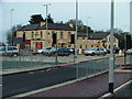
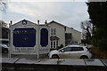
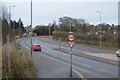
The George Hotel, Tavistock Road, Plymouth
The George Hotel, prior to recent 'road improvements' used to sit to the west of the T-junction of Plymbridge Road with the main A386 Tavistock Road. Following the roadworks it is the subject of planning applications which (I believe) might see its demolition and replacement with an enlarged hotel and public house complex.
Image: © Gwyn Jones
Taken: 27 Nov 2005
0.09 miles