IMAGES TAKEN NEAR TO
Speedwell Crescent, PLYMOUTH, PL6 5TH
Introduction
This page details the photographs taken nearby to Speedwell Crescent, PL6 5TH by members of the Geograph project.
The Geograph project started in 2005 with the aim of publishing, organising and preserving representative images for every square kilometre of Great Britain, Ireland and the Isle of Man.

There are currently over 7.5m images from over14,400 individuals and you can help contribute to the project by visiting https://www.geograph.org.uk
Image Map
Images are licensed for reuse under creativecommons.org/licenses/by-sa/2.0
Notes
- Clicking on the map will re-center to the selected point.
- The higher the marker number, the further away the image location is from the centre of the postcode.
Image Listing (25 Images Found)
Images are licensed for reuse under creativecommons.org/licenses/by-sa/2.0
Image
Details
Distance
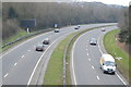
4
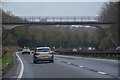
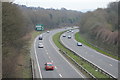
Plymouth : The Parkway A38
Looking along The Parkway in Plymouth.
Image: © Lewis Clarke
Taken: 17 Mar 2020
0.13 miles
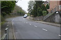
5
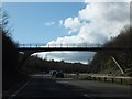
Footbridge over A38 north of Hollycroft Wood
Image: © David Smith
Taken: 18 Mar 2012
0.13 miles