IMAGES TAKEN NEAR TO
Lansdowne Road, PLYMOUTH, PL6 5ED
Introduction
This page details the photographs taken nearby to Lansdowne Road, PL6 5ED by members of the Geograph project.
The Geograph project started in 2005 with the aim of publishing, organising and preserving representative images for every square kilometre of Great Britain, Ireland and the Isle of Man.

There are currently over 7.5m images from over14,400 individuals and you can help contribute to the project by visiting https://www.geograph.org.uk
Image Map
Images are licensed for reuse under creativecommons.org/licenses/by-sa/2.0
Notes
- Clicking on the map will re-center to the selected point.
- The higher the marker number, the further away the image location is from the centre of the postcode.
Image Listing (65 Images Found)
Images are licensed for reuse under creativecommons.org/licenses/by-sa/2.0
Image
Details
Distance
5
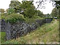
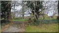
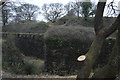
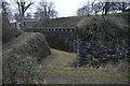
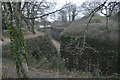
A corner of the wall and ditch of Crownhill Fort
One of the Palmerston Forts (later nicknamed Palmerston Follies) built to protect Plymouth naval dockyard from Napoleon III's potential invasion. The defeat of the French in the Franco-Prussian war made the threat unlikely. Crownhill Fort has been restored by the Landmark Trust
Image: © David Smith
Taken: 26 Sep 2014
0.13 miles