IMAGES TAKEN NEAR TO
Stanbury Avenue, PLYMOUTH, PL6 5AT
Introduction
This page details the photographs taken nearby to Stanbury Avenue, PL6 5AT by members of the Geograph project.
The Geograph project started in 2005 with the aim of publishing, organising and preserving representative images for every square kilometre of Great Britain, Ireland and the Isle of Man.

There are currently over 7.5m images from over14,400 individuals and you can help contribute to the project by visiting https://www.geograph.org.uk
Image Map
Images are licensed for reuse under creativecommons.org/licenses/by-sa/2.0
Notes
- Clicking on the map will re-center to the selected point.
- The higher the marker number, the further away the image location is from the centre of the postcode.
Image Listing (49 Images Found)
Images are licensed for reuse under creativecommons.org/licenses/by-sa/2.0
Image
Details
Distance

7
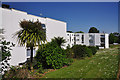
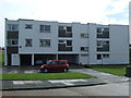
Apartment block on Tavistock Road - Plymouth
With the palm, bright blue sky and white of the building this photograph might easily be thought to have been taken on the shores of the Mediterranean.
Image: © Mick Lobb
Taken: 27 May 2010
0.09 miles