IMAGES TAKEN NEAR TO
Henley Drive, PLYMOUTH, PL5 4QA
Introduction
This page details the photographs taken nearby to Henley Drive, PL5 4QA by members of the Geograph project.
The Geograph project started in 2005 with the aim of publishing, organising and preserving representative images for every square kilometre of Great Britain, Ireland and the Isle of Man.

There are currently over 7.5m images from over14,400 individuals and you can help contribute to the project by visiting https://www.geograph.org.uk
Image Map
Images are licensed for reuse under creativecommons.org/licenses/by-sa/2.0
Notes
- Clicking on the map will re-center to the selected point.
- The higher the marker number, the further away the image location is from the centre of the postcode.
Image Listing (13 Images Found)
Images are licensed for reuse under creativecommons.org/licenses/by-sa/2.0
Image
Details
Distance
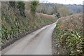
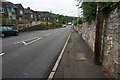
2
Roborough Lane, Tamerton Foliot
From its centre close to the valley floor, Tamerton Foliot develops mostly in a north easterly direction uphill along the old road to Roborough. As you climb Roborough Lane, 19th century housing gives way to early 20th century which in turn gives way to late 20th century housing towards the top of the hill. This photograph was taken looking northeast uphill.
Image: © Tony Atkin
Taken: 26 Nov 2005
0.16 miles
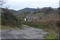
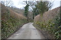
3
Whitsoncross Lane, Tamerton Foliot
Looking down the hill towards the centre of the village.
Image: © jeff collins
Taken: 13 Aug 2014
0.17 miles
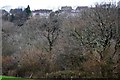
7
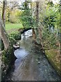
Stream, Tamerton Foliot
Tamerton stream at church row lane.
Image: © timothy luckham
Taken: 15 Nov 2019
0.23 miles
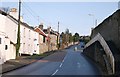
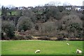
8
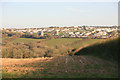
City and Countryside
A view across the valley , Southway part of Plymouth meets the countryside as seen from the Tamerton Road.
Image: © roger geach
Taken: 26 Mar 2012
0.24 miles