IMAGES TAKEN NEAR TO
Rock Hill, PLYMOUTH, PL5 4NY
Introduction
This page details the photographs taken nearby to Rock Hill, PL5 4NY by members of the Geograph project.
The Geograph project started in 2005 with the aim of publishing, organising and preserving representative images for every square kilometre of Great Britain, Ireland and the Isle of Man.

There are currently over 7.5m images from over14,400 individuals and you can help contribute to the project by visiting https://www.geograph.org.uk
Image Map
Images are licensed for reuse under creativecommons.org/licenses/by-sa/2.0
Notes
- Clicking on the map will re-center to the selected point.
- The higher the marker number, the further away the image location is from the centre of the postcode.
Image Listing (98 Images Found)
Images are licensed for reuse under creativecommons.org/licenses/by-sa/2.0
Image
Details
Distance
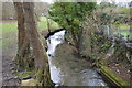
5
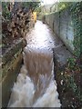
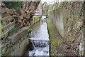
Tamerton Foliot Stream waterfall
Waterfall on Tamerton Foliot stream after a night of heavy rain.
Image: © timothy luckham
Taken: 3 Jan 2016
0.06 miles
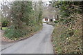
8
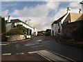
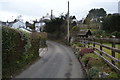
Whitsoncross Lane, Tamerton Foliot
The mini-roundabout (which is at the top of Fore Street) is at the junction with Horsham Lane (left), as the roads climb away from the centre of the village in its valley.
Image: © Derek Harper
Taken: 8 Nov 2008
0.07 miles