IMAGES TAKEN NEAR TO
Milford Lane, PLYMOUTH, PL5 4JP
Introduction
This page details the photographs taken nearby to Milford Lane, PL5 4JP by members of the Geograph project.
The Geograph project started in 2005 with the aim of publishing, organising and preserving representative images for every square kilometre of Great Britain, Ireland and the Isle of Man.

There are currently over 7.5m images from over14,400 individuals and you can help contribute to the project by visiting https://www.geograph.org.uk
Image Map
Images are licensed for reuse under creativecommons.org/licenses/by-sa/2.0
Notes
- Clicking on the map will re-center to the selected point.
- The higher the marker number, the further away the image location is from the centre of the postcode.
Image Listing (15 Images Found)
Images are licensed for reuse under creativecommons.org/licenses/by-sa/2.0
Image
Details
Distance
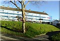
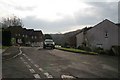
2
Holly Park views
View to the west from the Holly Park estate towards Ernesettle, a post WW2 housing estate. In the distance, Cornwall and the Saltash road bridge
Image: © Crispin Purdye
Taken: Unknown
0.06 miles
3
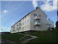
Winchester Gardens
Council flats in Whitleigh.
Image: © Burgess Von Thunen
Taken: 19 Sep 2012
0.06 miles
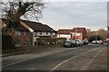
4
Taunton Avenue, Whitleigh - Plymouth
The view is across the valley between this post war housing estate toward another at West Park.
Image: © Mick Lobb
Taken: 5 Oct 2009
0.12 miles
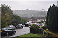
5
Truro Drive
The junction with Camborne Close off Truro Drive , Badgers Wood .
Image: © roger geach
Taken: 30 Nov 2008
0.12 miles
6
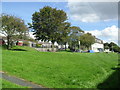
Norwich Avenue
Green space in Whitleigh.
Image: © Burgess Von Thunen
Taken: 19 Sep 2012
0.12 miles
7
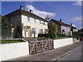
Winchester Gardens
Council houses in Whitleigh.
Image: © Burgess Von Thunen
Taken: 19 Sep 2012
0.14 miles
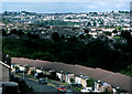
8

View of Cornwall from Whitleigh, Plymouth
When built to the north of Plymouth after the second world war, Whitleigh was something of a garden estate with open spaces and all facilities readily available; not to mention stunning views for some residents such as here. With today's generally declining standards and the expectation that someone else will provide the area is, like many where social cohesion has been lost, in decline. How different now from those days in the 'fifties when those allocated houses on the estate thought themselves to be so fortunate. To have a bathroom, a separate kitchen, several bedrooms, and a garden, was bliss indeed.
This view includes Tamerton Lake, just beyond the trees, another housing estate, Ernesettle, to its left and the River Tamar with Cornwall beyond that.
Image: © Mick Lobb
Taken: 2 Oct 2008
0.14 miles
10
Footpath towards the river
This is the footpath the leads from Badgers Wood estate towards the Tamerton Creek.
Image: © roger geach
Taken: 30 Nov 2008
0.18 miles