IMAGES TAKEN NEAR TO
Norwich Avenue, PLYMOUTH, PL5 4JF
Introduction
This page details the photographs taken nearby to Norwich Avenue, PL5 4JF by members of the Geograph project.
The Geograph project started in 2005 with the aim of publishing, organising and preserving representative images for every square kilometre of Great Britain, Ireland and the Isle of Man.

There are currently over 7.5m images from over14,400 individuals and you can help contribute to the project by visiting https://www.geograph.org.uk
Image Map
Images are licensed for reuse under creativecommons.org/licenses/by-sa/2.0
Notes
- Clicking on the map will re-center to the selected point.
- The higher the marker number, the further away the image location is from the centre of the postcode.
Image Listing (15 Images Found)
Images are licensed for reuse under creativecommons.org/licenses/by-sa/2.0
Image
Details
Distance
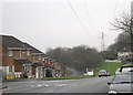
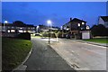
3
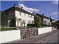
Winchester Gardens
Council houses in Whitleigh.
Image: © Burgess Von Thunen
Taken: 19 Sep 2012
0.09 miles
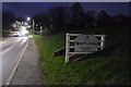
4
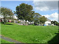
Norwich Avenue
Green space in Whitleigh.
Image: © Burgess Von Thunen
Taken: 19 Sep 2012
0.10 miles
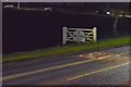
5
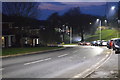
Underneath the Power Lines
On Budshead road by Westbury Close
Image: © Tony Atkin
Taken: 7 Jan 2006
0.15 miles
8
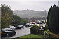
Taunton Avenue, Whitleigh - Plymouth
The view is across the valley between this post war housing estate toward another at West Park.
Image: © Mick Lobb
Taken: 5 Oct 2009
0.17 miles
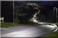
10
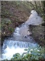
Stream, Budshead Wood
Stream flowing through Budshead Wood, Plymouth
Image: © timothy luckham
Taken: 3 Jan 2016
0.18 miles