IMAGES TAKEN NEAR TO
Budshead Road, PLYMOUTH, PL5 4DY
Introduction
This page details the photographs taken nearby to Budshead Road, PL5 4DY by members of the Geograph project.
The Geograph project started in 2005 with the aim of publishing, organising and preserving representative images for every square kilometre of Great Britain, Ireland and the Isle of Man.

There are currently over 7.5m images from over14,400 individuals and you can help contribute to the project by visiting https://www.geograph.org.uk
Image Map
Images are licensed for reuse under creativecommons.org/licenses/by-sa/2.0
Notes
- Clicking on the map will re-center to the selected point.
- The higher the marker number, the further away the image location is from the centre of the postcode.
Image Listing (22 Images Found)
Images are licensed for reuse under creativecommons.org/licenses/by-sa/2.0
Image
Details
Distance
4
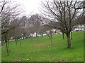
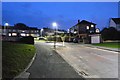
Whitleigh Green
This is a small area of green space at the centre of Whitleigh, a large postwar Council Housing estate.
Image: © Tony Atkin
Taken: 7 Jan 2006
0.06 miles
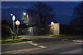
5
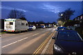
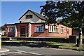
Engage Whitleigh - Plymouth
Formerly the Whitleigh Christian Centre the church has re-opened as Engage Whitleigh, a Pentecostal church in fellowship with the Assemblies of God which provides community based conferencing facilities as well as being a centre for religion.
Image: © Mick Lobb
Taken: 17 Jun 2010
0.06 miles
6
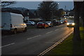
The Albemarle, Whitleigh - Plymouth
One of two local pubs built on the council estate that was built in the early fifties. One of them, The Tiger which was situated at the other end of the estate, has already closed and been demolished.
Image: © Mick Lobb
Taken: 17 Jun 2010
0.06 miles
8
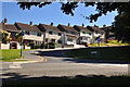
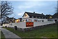
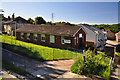
'Dolly Houses' on Whitleigh Green - Plymouth
Known to us as 'Dolly Houses' they were a basic design for providing housing in the city after the WW II when much of the housing stock and city itself had been destroyed. How we wanted to escape our little flat to live in one of these out in the countryside. Now many have been bought by their tenants as can be seen from the various 'improvements' and they have been swallowed up to form part of the social hurly burly and all that goes with it of the outer suburbs.
Image: © Mick Lobb
Taken: 17 Jun 2010
0.08 miles