IMAGES TAKEN NEAR TO
Old Woodlands Road, PLYMOUTH, PL5 3SY
Introduction
This page details the photographs taken nearby to Old Woodlands Road, PL5 3SY by members of the Geograph project.
The Geograph project started in 2005 with the aim of publishing, organising and preserving representative images for every square kilometre of Great Britain, Ireland and the Isle of Man.

There are currently over 7.5m images from over14,400 individuals and you can help contribute to the project by visiting https://www.geograph.org.uk
Image Map
Images are licensed for reuse under creativecommons.org/licenses/by-sa/2.0
Notes
- Clicking on the map will re-center to the selected point.
- The higher the marker number, the further away the image location is from the centre of the postcode.
Image Listing (20 Images Found)
Images are licensed for reuse under creativecommons.org/licenses/by-sa/2.0
Image
Details
Distance
1
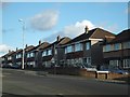
Houses on Crownhill Road
This row of semi-detached houses has a short service road in front
Image: © David Smith
Taken: 18 Mar 2012
0.09 miles
2
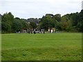
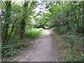
Playground and Woodland Woods
A small playground close to the Co-operative Way through Woodland Woods
Image: © David Smith
Taken: 26 Sep 2014
0.10 miles
3
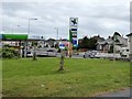
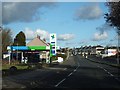
Filling station, Crownhill Road, Plymouth
The filling station is opposite the entrance to a large retail park; an advert for the Tesco store can be seen by the upright post advertising the price of fuel.
Image: © David Smith
Taken: 26 Sep 2014
0.12 miles
4
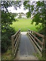
Footbridge in Woodland Woods
The bridge crosses the stream that separates Whitleigh and Honicknowle in Plymouth
Image: © David Smith
Taken: 26 Sep 2014
0.13 miles
5
Filling station in Crownhill Road
The stones on the left form part of the boundary of Woodland Fort Image
Image: © David Smith
Taken: 18 Mar 2012
0.13 miles
6
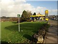
Petrol station, Honicknowle
A reverse view of Image, with the pricing restored on the Jet service station's sign.
Image: © Derek Harper
Taken: 19 Feb 2011
0.14 miles
7
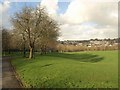
By Whitleigh Path
To the left is Whitleigh Path, leading away from Crownhill Road and crossing the valley to the Whitleigh estate, with trees casting shadows on the grass. Taken from the same place as Image
Image: © Derek Harper
Taken: 19 Feb 2011
0.16 miles
8
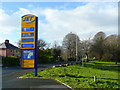
Filling station sign
By the B3413 Crownhill Road, Honicknowle, north of Plymouth city centre.
The pricing was on the blink!
Image: © Jonathan Billinger
Taken: 10 Dec 2008
0.16 miles
9
The Co-operative Way in Woodland Woods (2)
Part of the 15-mile long circular walk around northern Plymouth
Image: © David Smith
Taken: 26 Sep 2014
0.20 miles
10
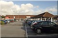
Tesco, Honicknowle
This seems quite a big store, but it's set to be demolished and replaced with an even bigger one, to be sited further west - ie behind the camera. Tesco has been here since 2001; the store was formerly a Plymco (Co-operative).
Image: © Derek Harper
Taken: 19 Feb 2011
0.20 miles