IMAGES TAKEN NEAR TO
Foxtor Close, PLYMOUTH, PL5 3RN
Introduction
This page details the photographs taken nearby to Foxtor Close, PL5 3RN by members of the Geograph project.
The Geograph project started in 2005 with the aim of publishing, organising and preserving representative images for every square kilometre of Great Britain, Ireland and the Isle of Man.

There are currently over 7.5m images from over14,400 individuals and you can help contribute to the project by visiting https://www.geograph.org.uk
Image Map
Images are licensed for reuse under creativecommons.org/licenses/by-sa/2.0
Notes
- Clicking on the map will re-center to the selected point.
- The higher the marker number, the further away the image location is from the centre of the postcode.
Image Listing (8 Images Found)
Images are licensed for reuse under creativecommons.org/licenses/by-sa/2.0
Image
Details
Distance
1
Housing at West Park
From the same place as Image; the block on the right is on Brayford Close, while the blocks dropping down the hill are on Lamerton Close. Across the Budshead valley is Whitleigh.
Image: © Derek Harper
Taken: 19 Feb 2011
0.09 miles
2
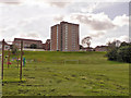
Tower block, Honicknowle, Plymouth
Am estate of 'prefabs' was established here immediately after the second world war. These were then replaced with prefabricated houses and blocks of flats as they became ready for replacement.
Image: © Mick Lobb
Taken: 3 Oct 2008
0.13 miles
3
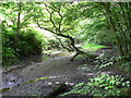
Carr woodland at Budshead Woods, Plymouth.
Image: © Mick Lobb
Taken: 2 Jul 2008
0.13 miles
4
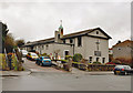
Parish Church of St Francis of Assisi, Honicknowle - Plymouth
Image: © Mick Lobb
Taken: 2 Feb 2010
0.15 miles
5
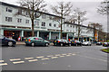
Honicknowle Green shops and flats - Plymouth
Image: © Mick Lobb
Taken: 2 Feb 2010
0.17 miles
6
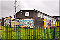
Honicknowle Youth & Community Centre - Plymouth
Image: © Mick Lobb
Taken: 2 Feb 2010
0.18 miles
7
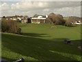
Football pitch, West Park
One of a pair of pitches on a recreation ground in front of Knowles Battery (see Image), seen from Cheriton Close. Knowle Primary School is visible above the ramparts.
Image: © Derek Harper
Taken: 19 Feb 2011
0.19 miles
8
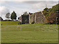
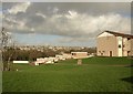
Knowles Battery, Plymouth
One of many of the Palmerston Fortifications to be found along the south coast. Knowles Battery was built in 1869 as one of a chain of fortifications for the defence of Plymouth.
The site beyond the ramparts is now occupied by Knowle Primary School and the playing fields a public open space.
Image: © Mick Lobb
Taken: 3 Oct 2008
0.21 miles