IMAGES TAKEN NEAR TO
Chaucer Way, PLYMOUTH, PL5 3EQ
Introduction
This page details the photographs taken nearby to Chaucer Way, PL5 3EQ by members of the Geograph project.
The Geograph project started in 2005 with the aim of publishing, organising and preserving representative images for every square kilometre of Great Britain, Ireland and the Isle of Man.

There are currently over 7.5m images from over14,400 individuals and you can help contribute to the project by visiting https://www.geograph.org.uk
Image Map
Images are licensed for reuse under creativecommons.org/licenses/by-sa/2.0
Notes
- Clicking on the map will re-center to the selected point.
- The higher the marker number, the further away the image location is from the centre of the postcode.
Image Listing (3 Images Found)
Images are licensed for reuse under creativecommons.org/licenses/by-sa/2.0
Image
Details
Distance
1
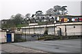
School and Houses
In the foreground, part of Chaucer Primary School with housing in the background
Image: © Tony Atkin
Taken: 7 Jan 2006
0.07 miles
2

The end of Cobbett Road, Honicknowle
The roads in this estate are named after British authors; local schools are named Chaucer and Shakespeare
Image: © David Smith
Taken: 26 Sep 2014
0.24 miles