IMAGES TAKEN NEAR TO
Coppice Gardens, PLYMOUTH, PL5 3DB
Introduction
This page details the photographs taken nearby to Coppice Gardens, PL5 3DB by members of the Geograph project.
The Geograph project started in 2005 with the aim of publishing, organising and preserving representative images for every square kilometre of Great Britain, Ireland and the Isle of Man.

There are currently over 7.5m images from over14,400 individuals and you can help contribute to the project by visiting https://www.geograph.org.uk
Image Map
Images are licensed for reuse under creativecommons.org/licenses/by-sa/2.0
Notes
- Clicking on the map will re-center to the selected point.
- The higher the marker number, the further away the image location is from the centre of the postcode.
Image Listing (9 Images Found)
Images are licensed for reuse under creativecommons.org/licenses/by-sa/2.0
Image
Details
Distance
1

An ill-fitting memorial - Manadon, Plymouth
Once standing proud above the portals of HMS Thunderer, the Royal Naval Engineering College,the turret stands beside the road, clad in plywood. Although initially planned as early as 1937 the foundation stone of the completed establishment was not laid until 1956. The building, of Portland stone, though of monoblock appearance lent a certain presence to the landscape of the area. With the decline of the Royal Navy in terms of manpower needs it went the way of all such institutions and training of naval engineering officers was transferred to Southampton University.
I hope there are plans to mount the turret on a more appealing base - perhaps of Portland stone, though I fear it is destined for another scrapyard.
Image: © Mick Lobb
Taken: 27 May 2010
0.06 miles
2
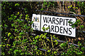
Street sign - Manadon, Plymouth
Reflecting past associations with the Royal Navy the streets are named after famous warships.
The first ship to bear the name was built at Deptford in 1758 and was a 74-gun third rate ship of the line of the Royal Navy. Latterly Warspite became one of the Royal Navy's most famous ships of the Twentieth Century serving with distinction in both world wars.
Image: © Mick Lobb
Taken: 27 May 2010
0.07 miles
3
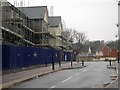
Frobisher Approach - Manadon, Plymouth
Once the approach to the Royal Naval Engineering College at Manadon it is now the approach to yet another sprawling housing estate. In accordance with modern thinking it comprises a mix of apartment blocks, mews, semi and detached houses crammed into as small a space as planning regulations allow.
Image: © Mick Lobb
Taken: 27 May 2010
0.08 miles
4

Crownhill Road, Plymouth
The B3413, here a dual carriageway heading across the northern Plymouth suburbs. This letterbox is at the junction with Whitleigh Avenue.
Image: © Derek Harper
Taken: 30 Mar 2012
0.12 miles
5
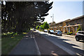
New Housing Development
The land on which these houses are built used to be the site of Manadon Royal Naval College which was vacated by the Navy and demolished a few years ago.
Image: © Tony Atkin
Taken: 7 Jan 2006
0.16 miles
6

Crownhill fire station
Crownhill fire station, Crownhill Road, Plymouth is station 49 of the Devon Fire & Rescue Service.
Image: © Kevin Hale
Taken: 3 Jul 2006
0.21 miles
7

Footpath and private land at Manadon - Plymouth
The footpath leads from the lower slopes of Manadon to the new housing estate built on the one time site of the old Royal Naval Engineering College.
Image: © Mick Lobb
Taken: 27 May 2010
0.25 miles
8

Footpath at Manadon - Plymouth
To the right are sports fields, including a football centre. On the other a large grassed area that seems destined for housing or associated development.
Image: © Mick Lobb
Taken: 27 May 2010
0.25 miles
9

The Co-operative Way in Woodland Woods (1)
The Co-operative Way is a circular walk around the north of Plymouth. Here it runs through Woodland Woods, the name having been taken from the nearby Woodland Fort
Image: © David Smith
Taken: 26 Sep 2014
0.25 miles