IMAGES TAKEN NEAR TO
St. Eval Place, PLYMOUTH, PL5 2RN
Introduction
This page details the photographs taken nearby to St. Eval Place, PL5 2RN by members of the Geograph project.
The Geograph project started in 2005 with the aim of publishing, organising and preserving representative images for every square kilometre of Great Britain, Ireland and the Isle of Man.

There are currently over 7.5m images from over14,400 individuals and you can help contribute to the project by visiting https://www.geograph.org.uk
Image Map
Images are licensed for reuse under creativecommons.org/licenses/by-sa/2.0
Notes
- Clicking on the map will re-center to the selected point.
- The higher the marker number, the further away the image location is from the centre of the postcode.
Image Listing (24 Images Found)
Images are licensed for reuse under creativecommons.org/licenses/by-sa/2.0
Image
Details
Distance
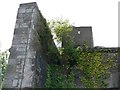
4
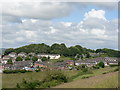
Agaton Fort overlooking Ernesettle, Plymouth.
Image: © Mick Lobb
Taken: 2 Jul 2008
0.09 miles
5
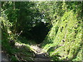
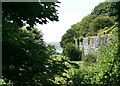
Dry moat, Agaton Fort. Plymouth.
The fort is to the right of this view with the ground to the left falling sharply downhill to the front and left.
Image: © Mick Lobb
Taken: 2 Jul 2008
0.09 miles
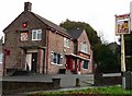
8
Hornchurch Lane, Ernesettle - Plymouth
'Lock ups' with a fruit and veg shop and the Ernesettle Information Centre.
Image: © Mick Lobb
Taken: 30 Jan 2010
0.12 miles
9
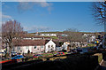
Croydon Gardens, Ernesettle - Plymouth
Immediately to the rear of the houses is 'the green' with farmland to the west of Tamerton Foliot in the far distance.
Image: © Mick Lobb
Taken: 30 Jan 2010
0.13 miles
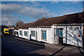
10
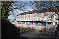
Shops and flats at Ernesettle Green - Plymouth
The shops include a 'Co-op' grocery store, a newsagent's and an Ivor Dewdney's pasty shop.
Image: © Mick Lobb
Taken: 30 Jan 2010
0.13 miles