IMAGES TAKEN NEAR TO
Crownhill Road, PLYMOUTH, PL5 2QU
Introduction
This page details the photographs taken nearby to Crownhill Road, PL5 2QU by members of the Geograph project.
The Geograph project started in 2005 with the aim of publishing, organising and preserving representative images for every square kilometre of Great Britain, Ireland and the Isle of Man.

There are currently over 7.5m images from over14,400 individuals and you can help contribute to the project by visiting https://www.geograph.org.uk
Image Map
Images are licensed for reuse under creativecommons.org/licenses/by-sa/2.0
Notes
- Clicking on the map will re-center to the selected point.
- The higher the marker number, the further away the image location is from the centre of the postcode.
Image Listing (31 Images Found)
Images are licensed for reuse under creativecommons.org/licenses/by-sa/2.0
Image
Details
Distance
3
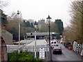
Commercial Reclamation Centre
The tower of St Budeaux Church is visible in the background.
Image: © Tony Atkin
Taken: 7 Jan 2006
0.11 miles
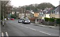
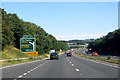
5
Plymouth : The A38
The A38 heading through the city of Plymouth.
Image: © Lewis Clarke
Taken: 17 Jul 2015
0.17 miles
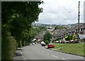
7
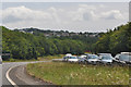
The A38
The outstirts of Plymouth at Weston Mill.
Image: © Robert Ashby
Taken: 8 Aug 2015
0.18 miles
9
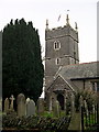
St Budeaux Church
This is the tower and south porch of St Budeaux Church.
Image: © Tony Atkin
Taken: 7 Jan 2006
0.18 miles