IMAGES TAKEN NEAR TO
Hill Path, PLYMOUTH, PL5 2QF
Introduction
This page details the photographs taken nearby to Hill Path, PL5 2QF by members of the Geograph project.
The Geograph project started in 2005 with the aim of publishing, organising and preserving representative images for every square kilometre of Great Britain, Ireland and the Isle of Man.

There are currently over 7.5m images from over14,400 individuals and you can help contribute to the project by visiting https://www.geograph.org.uk
Image Map
Images are licensed for reuse under creativecommons.org/licenses/by-sa/2.0
Notes
- Clicking on the map will re-center to the selected point.
- The higher the marker number, the further away the image location is from the centre of the postcode.
Image Listing (19 Images Found)
Images are licensed for reuse under creativecommons.org/licenses/by-sa/2.0
Image
Details
Distance
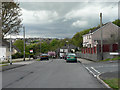
1
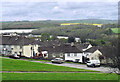
Lympne Avenue, Ernesettle - Plymouth
Viewed from the top of Rochford Crescent with views to Cornwall and Kit Hill across the River Tamar.
Image: © Mick Lobb
Taken: 1 May 2010
0.05 miles
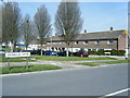
3
Mill Ford School, Ernesettle - Plymouth
Mill Ford caters for pupils with severe, profound and multiple and autism related learning difficulties.
Image: © Mick Lobb
Taken: 1 May 2010
0.10 miles
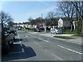
8
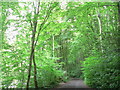
Budshead Wood, Plymouth.
Recognised as dating from the Middle Ages this is a mixed woodland of ash and beech and containing hornbeam indicating later planting. Contains a varied habitat in its relatively small area.
Image: © Mick Lobb
Taken: 2 Jul 2008
0.19 miles
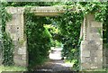
9
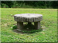
Millstone seat. Ernesettle, Plymouth.
Adjacent to this seat once stood what I seem to remember was a ruined Elizabethan structure, possibly a barn. Certainly in the '50's when it was restored and put into use as a library it was known as 'Ernesettle Barn'. Close by stand two gateways also featured on this web site.
Image: © Mick Lobb
Taken: 2 Jul 2008
0.19 miles