IMAGES TAKEN NEAR TO
Crownhill Road, PLYMOUTH, PL5 2HQ
Introduction
This page details the photographs taken nearby to Crownhill Road, PL5 2HQ by members of the Geograph project.
The Geograph project started in 2005 with the aim of publishing, organising and preserving representative images for every square kilometre of Great Britain, Ireland and the Isle of Man.

There are currently over 7.5m images from over14,400 individuals and you can help contribute to the project by visiting https://www.geograph.org.uk
Image Map
Images are licensed for reuse under creativecommons.org/licenses/by-sa/2.0
Notes
- Clicking on the map will re-center to the selected point.
- The higher the marker number, the further away the image location is from the centre of the postcode.
Image Listing (12 Images Found)
Images are licensed for reuse under creativecommons.org/licenses/by-sa/2.0
Image
Details
Distance
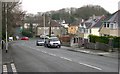
1
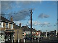
Shops in Crownhill Road
The shops and post office at the junction with Parade Road
Image: © David Smith
Taken: 18 Mar 2012
0.06 miles
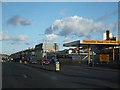
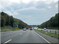
5
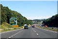
The A38
The outstirts of Plymouth at Weston Mill.
Image: © Robert Ashby
Taken: 8 Aug 2015
0.20 miles
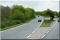
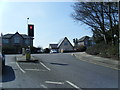
10
A38 Plymouth Weston Hill Junction Ahead
Image: © Roy Hughes
Taken: 16 Sep 2015
0.22 miles