IMAGES TAKEN NEAR TO
Coombe Way, PLYMOUTH, PL5 2HB
Introduction
This page details the photographs taken nearby to Coombe Way, PL5 2HB by members of the Geograph project.
The Geograph project started in 2005 with the aim of publishing, organising and preserving representative images for every square kilometre of Great Britain, Ireland and the Isle of Man.

There are currently over 7.5m images from over14,400 individuals and you can help contribute to the project by visiting https://www.geograph.org.uk
Image Map
Images are licensed for reuse under creativecommons.org/licenses/by-sa/2.0
Notes
- Clicking on the map will re-center to the selected point.
- The higher the marker number, the further away the image location is from the centre of the postcode.
Image Listing (5 Images Found)
Images are licensed for reuse under creativecommons.org/licenses/by-sa/2.0
Image
Details
Distance
1
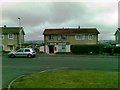
Our Shop, King's Tamerton Road, Plymouth
Image: © Alex McGregor
Taken: 15 Jun 2011
0.12 miles
2
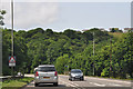
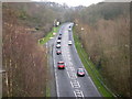
Plymouth : St Budeaux Bypass, A3064
The A3064 heading into the city of Plymouth.
Image: © Lewis Clarke
Taken: 17 Jul 2015
0.16 miles
3
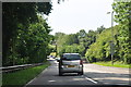
Plymouth : St Budeaux Bypass, A3064
Heading along the bypass and into Plymouth.
Image: © Lewis Clarke
Taken: 17 Jul 2015
0.16 miles
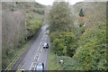
4
Weston Mill Drive
Weston Mill Drive is a feeder road linking the Devonport Naval Base to Plymouth Parkway. This photo was taken from a road crossing on an overpass.
Image: © Tony Atkin
Taken: 7 Jan 2006
0.20 miles