IMAGES TAKEN NEAR TO
Hill Top Crest, PLYMOUTH, PL5 2DY
Introduction
This page details the photographs taken nearby to Hill Top Crest, PL5 2DY by members of the Geograph project.
The Geograph project started in 2005 with the aim of publishing, organising and preserving representative images for every square kilometre of Great Britain, Ireland and the Isle of Man.

There are currently over 7.5m images from over14,400 individuals and you can help contribute to the project by visiting https://www.geograph.org.uk
Image Map
Images are licensed for reuse under creativecommons.org/licenses/by-sa/2.0
Notes
- Clicking on the map will re-center to the selected point.
- The higher the marker number, the further away the image location is from the centre of the postcode.
Image Listing (16 Images Found)
Images are licensed for reuse under creativecommons.org/licenses/by-sa/2.0
Image
Details
Distance
1
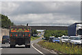
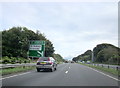
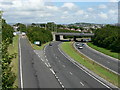
Plymouth : The A38
The A38 Devon Expressway heading through Plymouth.
Image: © Lewis Clarke
Taken: 17 Jul 2015
0.13 miles
2
Footbridge over A38 from Ernesettle Lane
This bridge follows the former route of Ernesettle Lane from the north (right). Traffic on the lane follows the new route, and runs alongside the A38 to a road bridge behind the photographer.
Image: © David Smith
Taken: 18 Mar 2012
0.14 miles
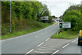
3
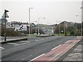
Old Road - New Road
The road in the distance is the Plymouth Parkway which takes traffic through Plymouth and over the Tamar Road Bridge into Cornwall. The Parkway replaced the narrower road in the foreground which has been converted from a dual carriageway to a single carriageway with a cycle lane. The road is clear of traffic but it is in fact very busy. The photographer had to wait about 10 minutes to get this traffic-free shot.
Image: © Tony Atkin
Taken: 7 Jan 2006
0.14 miles
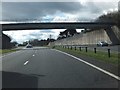
4

Westbound A38 approaching the Tamar Bridge
Image: © David Dixon
Taken: 13 Apr 2022
0.16 miles
5
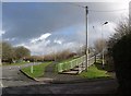
Path, road and steps, Ernesettle
From Ernesettle Crescent. Ernesettle Lane is on the left. The path and, more directly, the steps, are climbing to meet a nearby footbridge across the A38 Parkway.
Image: © Derek Harper
Taken: 19 Feb 2011
0.17 miles
8
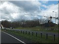
A38 near Ernesettle
To the north of the A38 (Parkway) was this tower crane.
Image: © David Smith
Taken: 18 Mar 2012
0.19 miles
9
Plymouth : The A38 Sliproad
A sliproad off of the A38 and onto the B3413.
Image: © Lewis Clarke
Taken: 17 Jul 2015
0.20 miles
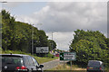
10
A38 and slip road to St Budeaux, Plymouth.
Image: © Mick Lobb
Taken: 2 Jul 2008
0.20 miles