IMAGES TAKEN NEAR TO
Wakefield Avenue, PLYMOUTH, PL5 1PU
Introduction
This page details the photographs taken nearby to Wakefield Avenue, PL5 1PU by members of the Geograph project.
The Geograph project started in 2005 with the aim of publishing, organising and preserving representative images for every square kilometre of Great Britain, Ireland and the Isle of Man.

There are currently over 7.5m images from over14,400 individuals and you can help contribute to the project by visiting https://www.geograph.org.uk
Image Map
Images are licensed for reuse under creativecommons.org/licenses/by-sa/2.0
Notes
- Clicking on the map will re-center to the selected point.
- The higher the marker number, the further away the image location is from the centre of the postcode.
Image Listing (10 Images Found)
Images are licensed for reuse under creativecommons.org/licenses/by-sa/2.0
Image
Details
Distance
2
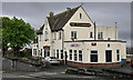
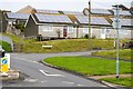
The Fellowship, Trevithick Road - Plymouth
Image: © Mick Lobb
Taken: 1 May 2010
0.15 miles
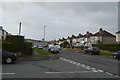
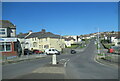
3

Fletemoor Road, St Budeaux
The road climbs through the large estate at St Budeaux. Seen from the junction with Moor Lane. Not sure what is happening behind the barricades on the left, but there used to be a triangular green on the corner.
Image: © Derek Harper
Taken: 9 Feb 2010
0.17 miles
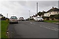
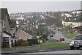
4
Tamarside Community College
Tamarside is a modern secondary school in the west of Plymouth.
Image: © Tony Atkin
Taken: 7 Jan 2006
0.20 miles
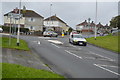
5
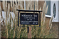
Road sign, Normandy Way - Plymouth
The road was a major route to the embarkation points on the banks of the Tamar in support of the D-Day landings of 1944. The road carried troops of V and VII Corps US Army to their departure craft in Saltash Passage. Their destinations were Omaha and Utah beaches. US Forces suffered their heaviest casualties on Omaha beach. Previously known as Tamar Terrace the road was renamed Normandy Way in their honour.
Image: © Mick Lobb
Taken: 18 Mar 2010
0.21 miles