IMAGES TAKEN NEAR TO
Pemros Road, PLYMOUTH, PL5 1NE
Introduction
This page details the photographs taken nearby to Pemros Road, PL5 1NE by members of the Geograph project.
The Geograph project started in 2005 with the aim of publishing, organising and preserving representative images for every square kilometre of Great Britain, Ireland and the Isle of Man.

There are currently over 7.5m images from over14,400 individuals and you can help contribute to the project by visiting https://www.geograph.org.uk
Image Map
Images are licensed for reuse under creativecommons.org/licenses/by-sa/2.0
Notes
- Clicking on the map will re-center to the selected point.
- The higher the marker number, the further away the image location is from the centre of the postcode.
Image Listing (72 Images Found)
Images are licensed for reuse under creativecommons.org/licenses/by-sa/2.0
Image
Details
Distance
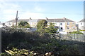
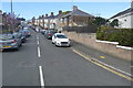
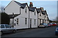
1
Pemros Road
This suburban street used to be a busy thoroughfare taking traffic from western Plymouth to the Tamar Bridge but now the only access to the bridge from this road is for buses.
Image: © Tony Atkin
Taken: 25 May 2008
0.02 miles
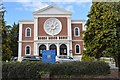
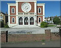
2
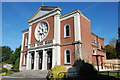
St Paul's RC Church, St Budeaux
St Paul's was built in 1933, in the style of the Roman basilica St Paul's outside the walls.
Image: © Tim Lewis
Taken: 27 Sep 2007
0.03 miles