IMAGES TAKEN NEAR TO
Normandy Hill, PLYMOUTH, PL5 1LR
Introduction
This page details the photographs taken nearby to Normandy Hill, PL5 1LR by members of the Geograph project.
The Geograph project started in 2005 with the aim of publishing, organising and preserving representative images for every square kilometre of Great Britain, Ireland and the Isle of Man.

There are currently over 7.5m images from over14,400 individuals and you can help contribute to the project by visiting https://www.geograph.org.uk
Image Map
Images are licensed for reuse under creativecommons.org/licenses/by-sa/2.0
Notes
- Clicking on the map will re-center to the selected point.
- The higher the marker number, the further away the image location is from the centre of the postcode.
Image Listing (190 Images Found)
Images are licensed for reuse under creativecommons.org/licenses/by-sa/2.0
Image
Details
Distance
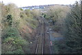
4
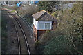
Bridge over the railway, Normandy Hill, Plymouth (2)
This bridge crosses the main line into Cornwall, to Saltash and beyond. A short distance down the same hill is another bridge over a railway line, this time the branch line to Gunnislake. See Image
Image: © Ruth Sharville
Taken: 29 Jun 2023
0.03 miles
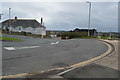
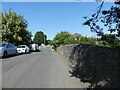
5
Footpath between Normandy Way and Normandy Hill - Plymouth
I think that Normandy Way and Normandy Hill would previously have been directly linked. The new road bridge across the Tamar would have resulted in these being cut off from one another. Normandy Way now terminates in a vehicle turning point with this footpath leading to the waterfront and to the bridges seen in the background.
Image: © Mick Lobb
Taken: 18 Mar 2010
0.04 miles
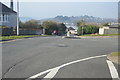
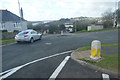
8
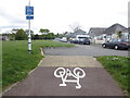
End of Cycle Route, Normandy Way
Route from Tamar Bridge via Pemros Road.
Image: © Peter Holmes
Taken: 7 May 2014
0.06 miles