IMAGES TAKEN NEAR TO
Foulston Avenue, PLYMOUTH, PL5 1HJ
Introduction
This page details the photographs taken nearby to Foulston Avenue, PL5 1HJ by members of the Geograph project.
The Geograph project started in 2005 with the aim of publishing, organising and preserving representative images for every square kilometre of Great Britain, Ireland and the Isle of Man.

There are currently over 7.5m images from over14,400 individuals and you can help contribute to the project by visiting https://www.geograph.org.uk
Image Map
Images are licensed for reuse under creativecommons.org/licenses/by-sa/2.0
Notes
- Clicking on the map will re-center to the selected point.
- The higher the marker number, the further away the image location is from the centre of the postcode.
Image Listing (39 Images Found)
Images are licensed for reuse under creativecommons.org/licenses/by-sa/2.0
Image
Details
Distance
3
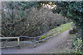
Path, Kinterbury Creek Nature Reserve
See http://www.plymouth.gov.uk/kinterburycreekcws for more details.
Image: © N Chadwick
Taken: 14 Feb 2016
0.09 miles
7
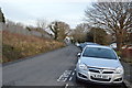
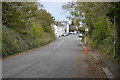
Barne Road, Barne Barton
Taken a couple of weeks after the sad death of the famous bus-travelling cat Caspar, who lived in Barne Barton http://www.thisisplymouth.co.uk/news/Celebrity-cat-killed-hit-run/article-1718680-detail/article.html . Barne Road is one of the principal roads through the estate.
Image: © Derek Harper
Taken: 9 Feb 2010
0.10 miles
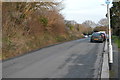
8

Kinterbury Creek Nature Reserve
See http://www.plymouth.gov.uk/kinterburycreekcws for more details.
Image: © N Chadwick
Taken: 14 Feb 2016
0.12 miles
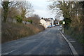
10
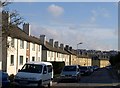
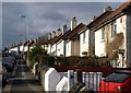
Fegan Road, Barne Barton
Sunlit terraces, white and yellow, on the north side of a road that forms the northern edge of the estate near Kinterbury Creek.
Image: © Derek Harper
Taken: 9 Feb 2010
0.12 miles