IMAGES TAKEN NEAR TO
York Road, PLYMOUTH, PL5 1AT
Introduction
This page details the photographs taken nearby to York Road, PL5 1AT by members of the Geograph project.
The Geograph project started in 2005 with the aim of publishing, organising and preserving representative images for every square kilometre of Great Britain, Ireland and the Isle of Man.

There are currently over 7.5m images from over14,400 individuals and you can help contribute to the project by visiting https://www.geograph.org.uk
Image Map
Images are licensed for reuse under creativecommons.org/licenses/by-sa/2.0
Notes
- Clicking on the map will re-center to the selected point.
- The higher the marker number, the further away the image location is from the centre of the postcode.
Image Listing (71 Images Found)
Images are licensed for reuse under creativecommons.org/licenses/by-sa/2.0
Image
Details
Distance
1
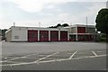
Camels Head fire station
Camels Head fire station, Ferndale Road, Camels Head, Plymouth is station 48 of the Devon Fire & Rescue Service. It also houses the Commercial Training School.
Image: © Kevin Hale
Taken: 3 Jul 2006
0.06 miles
2
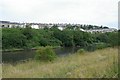
Weston Mill lake
The northern end of Weston Mill lake, opposite Camels Head fire station, Plymouth.
Image: © Kevin Hale
Taken: 3 Jul 2006
0.06 miles
4
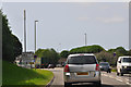
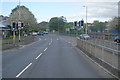
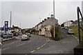
Plymouth : St Budeaux Bypass, A3064
Heading along St Budeaux Bypass and into the city of Plymouth.
Image: © Lewis Clarke
Taken: 17 Jul 2015
0.08 miles