IMAGES TAKEN NEAR TO
Mainstone Avenue, PLYMOUTH, PL4 9NB
Introduction
This page details the photographs taken nearby to Mainstone Avenue, PL4 9NB by members of the Geograph project.
The Geograph project started in 2005 with the aim of publishing, organising and preserving representative images for every square kilometre of Great Britain, Ireland and the Isle of Man.

There are currently over 7.5m images from over14,400 individuals and you can help contribute to the project by visiting https://www.geograph.org.uk
Image Map
Images are licensed for reuse under creativecommons.org/licenses/by-sa/2.0
Notes
- Clicking on the map will re-center to the selected point.
- The higher the marker number, the further away the image location is from the centre of the postcode.
Image Listing (129 Images Found)
Images are licensed for reuse under creativecommons.org/licenses/by-sa/2.0
Image
Details
Distance
1
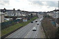
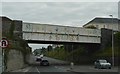
Gdynia Way, Prince Rock, Plymouth
Now part of the main 'road' route into the city centre, from the east, Gdynia Way follows the line of the former railway that served Sutton Harbour, cutting between the back gardens of the streets on either side.
Image: © Gwyn Jones
Taken: 4 Oct 2005
0.05 miles
2

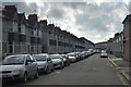
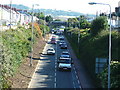
Plymouth : Gdynia Way
Looking along Gdynia Way in Plymouth.
Image: © Lewis Clarke
Taken: 22 May 2013
0.05 miles