IMAGES TAKEN NEAR TO
Egerton Road, PLYMOUTH, PL4 9BR
Introduction
This page details the photographs taken nearby to Egerton Road, PL4 9BR by members of the Geograph project.
The Geograph project started in 2005 with the aim of publishing, organising and preserving representative images for every square kilometre of Great Britain, Ireland and the Isle of Man.

There are currently over 7.5m images from over14,400 individuals and you can help contribute to the project by visiting https://www.geograph.org.uk
Image Map
Images are licensed for reuse under creativecommons.org/licenses/by-sa/2.0
Notes
- Clicking on the map will re-center to the selected point.
- The higher the marker number, the further away the image location is from the centre of the postcode.
Image Listing (156 Images Found)
Images are licensed for reuse under creativecommons.org/licenses/by-sa/2.0
Image
Details
Distance
1
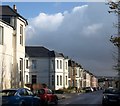
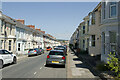
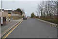
Knighton Road, Plymouth
These terraces with canted bays, bright in the sunshine, face Image The junction is with Greenbank Avenue.
Image: © Derek Harper
Taken: 8 Nov 2008
0.05 miles
2
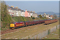
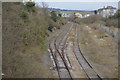
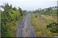
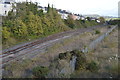
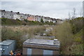
Plymouth Friary
Special passenger train visiting Plymouth Friary Yard.
Image: © Wayland Smith
Taken: 27 Mar 2007
0.07 miles