IMAGES TAKEN NEAR TO
Beaumont Road, PLYMOUTH, PL4 9BA
Introduction
This page details the photographs taken nearby to Beaumont Road, PL4 9BA by members of the Geograph project.
The Geograph project started in 2005 with the aim of publishing, organising and preserving representative images for every square kilometre of Great Britain, Ireland and the Isle of Man.

There are currently over 7.5m images from over14,400 individuals and you can help contribute to the project by visiting https://www.geograph.org.uk
Image Map
Images are licensed for reuse under creativecommons.org/licenses/by-sa/2.0
Notes
- Clicking on the map will re-center to the selected point.
- The higher the marker number, the further away the image location is from the centre of the postcode.
Image Listing (822 Images Found)
Images are licensed for reuse under creativecommons.org/licenses/by-sa/2.0
Image
Details
Distance
3
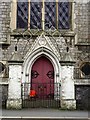
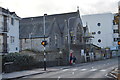
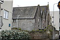
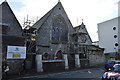
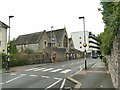
Holy Cross Church, Plymouth
On Ebrington Street. "The Holy Cross church ... is a decent Victorian Gothick building with attached presbytery and rebuilt primary school, which adds undoubt
ed interest to the street scene" http://www.plymouth.gov.uk/0803_ebrington_street_conservation_area_draft_appraisal_and_management_plan_-_landscape_final-pt6-2.pdf .
Image: © Derek Harper
Taken: 7 Mar 2015
0.02 miles
8
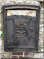
Tramway plate, Beaumont Road, Plymouth
The Plymouth Corporation tram routes were on the east side of the city. This route was the first to be electrified, in 1899, but the trams ceased was in 1936. This plaque is on the wall in front of Beaumont House.
Image: © Derek Harper
Taken: 7 Mar 2015
0.04 miles
9
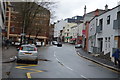
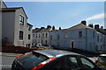
Zebra crossing on Beaumont Street
Beyond it on the far side of the road is Holy Cross Primary School Image
Image: © Stephen Craven
Taken: 30 Jun 2023
0.04 miles
10
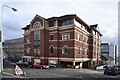
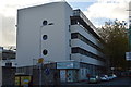
West Point office block, Ebrington Street - Plymouth
Previously the site of the Ham Street Wesleyan Chapel it gained greater note after the latter burnt down in 1937 when the ruin was purchased by a Mr James William Selleck whose own bakery had been destroyed in the blitz of 1941. I well remember the stone steps leading up to the restaurant then the bare wooden ones leading up to long counter over which pasties could be purchased. As a pupil of the nearby Sutton High School I would go to the bakery door just down the hill to buy my lunch straight from the oven! How times have changed!
Image: © Mick Lobb
Taken: 25 Nov 2009
0.04 miles