IMAGES TAKEN NEAR TO
Pentyre Terrace, PLYMOUTH, PL4 8RP
Introduction
This page details the photographs taken nearby to Pentyre Terrace, PL4 8RP by members of the Geograph project.
The Geograph project started in 2005 with the aim of publishing, organising and preserving representative images for every square kilometre of Great Britain, Ireland and the Isle of Man.

There are currently over 7.5m images from over14,400 individuals and you can help contribute to the project by visiting https://www.geograph.org.uk
Image Map
Images are licensed for reuse under creativecommons.org/licenses/by-sa/2.0
Notes
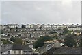
- Clicking on the map will re-center to the selected point.
- The higher the marker number, the further away the image location is from the centre of the postcode.
Image Listing (23 Images Found)
Images are licensed for reuse under creativecommons.org/licenses/by-sa/2.0
Image
Details
Distance
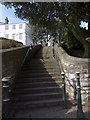
2
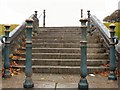
Granite steps Freedom Fields Plymouth
Given a chance these steps could survive for as long as the Great Pyramids have - the bollards and rails too if spared by scrap metal thieves!
Image: © Mick Lobb
Taken: 4 Oct 2008
0.08 miles
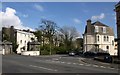
3

Mount Gould Road
Viewed from the junction with Lipsom Road.
Image: © Mark Anderson
Taken: 29 Jun 2023
0.09 miles
4
Mount Gould Road
Seen across Lipson Road from the corner of Freedom Fields Park. On the left is the early C19 Lipson Terrace http://www.imagesofengland.org.uk/details/default.aspx?id=473639 with its "charming little octagonal lodges" (Cherry & Pevsner) http://www.imagesofengland.org.uk/Details/Default.aspx?id=473640&mode=adv . Opposite, at the corner of Sea View Avenue, is a decidedly French lipped mansard roof.
Image: © Derek Harper
Taken: 27 Mar 2010
0.10 miles
5
Lodges, Lipson Terrace, Plymouth
An octagonal pair guarding the entrance to Image Grade II listed.
Their guarding days seem to be over.
Image: © Stephen Richards
Taken: 17 Jun 2014
0.10 miles
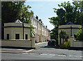
6
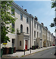
Lipson Terrace, Plymouth
A fine early C19th terrace of seven 3-bay houses. Unusually, the first-floor windows are round-arched. Grade II listed.
Image: © Stephen Richards
Taken: 17 Jun 2014
0.10 miles
7

Lipson Terrace
The terrace seen on the left of Image from between its lodges. The early C19 terrace with its protruding porches is described at http://www.imagesofengland.org.uk/Details/Default.aspx?id=473639&mode=adv .
Image: © Derek Harper
Taken: 27 Mar 2010
0.10 miles
8
Steps to Freedom Fields
A flight of steps leads from Lipson Road up to the southwest corner of the park. The metal posts match those further up the road shown in Image The white house is on Woodside.
Image: © Derek Harper
Taken: 27 Mar 2010
0.12 miles
9
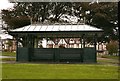
People Shelter Freedom Fields Plymouth
From here one can see the Sound. Plymouth Sound!
Image: © Mick Lobb
Taken: 4 Oct 2008
0.12 miles
10
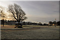
Freedom Fields Park - Plymouth
The park is situated at the top of a slope rising from the cliffs of the Sound to the south and drops away again to the north.
Image: © Mick Lobb
Taken: 31 Jan 2010
0.12 miles