IMAGES TAKEN NEAR TO
May Terrace, PLYMOUTH, PL4 8PP
Introduction
This page details the photographs taken nearby to May Terrace, PL4 8PP by members of the Geograph project.
The Geograph project started in 2005 with the aim of publishing, organising and preserving representative images for every square kilometre of Great Britain, Ireland and the Isle of Man.

There are currently over 7.5m images from over14,400 individuals and you can help contribute to the project by visiting https://www.geograph.org.uk
Image Map
Images are licensed for reuse under creativecommons.org/licenses/by-sa/2.0
Notes
- Clicking on the map will re-center to the selected point.
- The higher the marker number, the further away the image location is from the centre of the postcode.
Image Listing (158 Images Found)
Images are licensed for reuse under creativecommons.org/licenses/by-sa/2.0
Image
Details
Distance
1
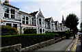
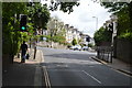
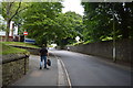
The B3238
Very attractive terrace of stone houses along this road into Plymouth.
Image: © Robert Ashby
Taken: 4 Aug 2015
0.04 miles
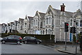
9
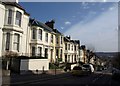
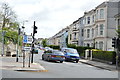
Greenbank Avenue, Plymouth
One of several streets of pleasant canted-bay-fronted terraces, which drop down with dramatic views to Cattewater and beyond.
Image: © Derek Harper
Taken: 27 Mar 2010
0.09 miles