IMAGES TAKEN NEAR TO
Hospital Road, PLYMOUTH, PL4 8NP
Introduction
This page details the photographs taken nearby to Hospital Road, PL4 8NP by members of the Geograph project.
The Geograph project started in 2005 with the aim of publishing, organising and preserving representative images for every square kilometre of Great Britain, Ireland and the Isle of Man.

There are currently over 7.5m images from over14,400 individuals and you can help contribute to the project by visiting https://www.geograph.org.uk
Image Map
Images are licensed for reuse under creativecommons.org/licenses/by-sa/2.0
Notes
- Clicking on the map will re-center to the selected point.
- The higher the marker number, the further away the image location is from the centre of the postcode.
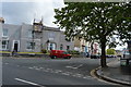
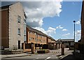
Image Listing (203 Images Found)
Images are licensed for reuse under creativecommons.org/licenses/by-sa/2.0
Image
Details
Distance
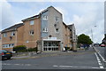
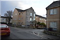
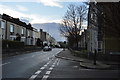
5
Seven Trees Court
These modern flats now occupy the site of what used to be Greenbank Hospital. I would be interested to know where the seven trees are or were.
Image: © Tony Atkin
Taken: 28 May 2007
0.06 miles
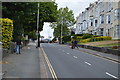
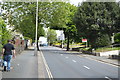
7
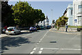
Greenbank Road
Viewed from the junction with Greenbank Terrace.
Image: © Mark Anderson
Taken: 29 Jun 2023
0.07 miles