IMAGES TAKEN NEAR TO
Cobble Mews, PLYMOUTH, PL4 8FF
Introduction
This page details the photographs taken nearby to Cobble Mews, PL4 8FF by members of the Geograph project.
The Geograph project started in 2005 with the aim of publishing, organising and preserving representative images for every square kilometre of Great Britain, Ireland and the Isle of Man.

There are currently over 7.5m images from over14,400 individuals and you can help contribute to the project by visiting https://www.geograph.org.uk
Image Map
Images are licensed for reuse under creativecommons.org/licenses/by-sa/2.0
Notes
- Clicking on the map will re-center to the selected point.
- The higher the marker number, the further away the image location is from the centre of the postcode.
Image Listing (353 Images Found)
Images are licensed for reuse under creativecommons.org/licenses/by-sa/2.0
Image
Details
Distance

6
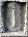
Old Guide Stone by the B3238, Greenbank Road, Plymouth
Guide Stone by the B3238, in parish of Plymouth (Plymouth District), Greenbank Road (Alexandra Place), 20m from junction, in wall at end of Cheltenham Place, on pavement in recess of wall (moved from junction).
Grade II listed.
List Entry Number: 1113302 https://historicengland.org.uk/listing/the-list/list-entry/1113302
Surveyed
Milestone Society National ID: DV_PLTV01x
Image: © Tim Jenkinson
Taken: 23 Jul 2010
0.04 miles