IMAGES TAKEN NEAR TO
Regent Street, PLYMOUTH, PL4 8BP
Introduction
This page details the photographs taken nearby to Regent Street, PL4 8BP by members of the Geograph project.
The Geograph project started in 2005 with the aim of publishing, organising and preserving representative images for every square kilometre of Great Britain, Ireland and the Isle of Man.

There are currently over 7.5m images from over14,400 individuals and you can help contribute to the project by visiting https://www.geograph.org.uk
Image Map
Images are licensed for reuse under creativecommons.org/licenses/by-sa/2.0
Notes
- Clicking on the map will re-center to the selected point.
- The higher the marker number, the further away the image location is from the centre of the postcode.
Image Listing (748 Images Found)
Images are licensed for reuse under creativecommons.org/licenses/by-sa/2.0
Image
Details
Distance
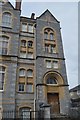
1

White Cross Court
This used to be the site of the Underhills printing works which was demolished in the 1970's. It was then used as a car park for many years before these flats were built.
Image: © Tony Atkin
Taken: 28 May 2007
0.01 miles
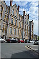
7
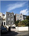
Gascoyne Place, Plymouth
Some of the houses in the early C19 terrace on Lipson Road have retained their slate-hung facades, and these are listed http://www.imagesofengland.org.uk/Details/Default.aspx?id=473559&mode=adv .
Image: © Derek Harper
Taken: 27 Mar 2010
0.03 miles