IMAGES TAKEN NEAR TO
Connaught Avenue, PLYMOUTH, PL4 7BY
Introduction
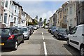
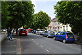
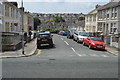
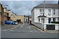
This page details the photographs taken nearby to Connaught Avenue, PL4 7BY by members of the Geograph project.
The Geograph project started in 2005 with the aim of publishing, organising and preserving representative images for every square kilometre of Great Britain, Ireland and the Isle of Man.

There are currently over 7.5m images from over14,400 individuals and you can help contribute to the project by visiting https://www.geograph.org.uk
Image Map
Images are licensed for reuse under creativecommons.org/licenses/by-sa/2.0
Notes
- Clicking on the map will re-center to the selected point.
- The higher the marker number, the further away the image location is from the centre of the postcode.
Image Listing (180 Images Found)
Images are licensed for reuse under creativecommons.org/licenses/by-sa/2.0
Image
Details
Distance
6
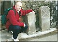
Old Boundary Markers on Elm Road, Plymouth
Two Municipal Boundary Markers in Plymouth on the north side of Elm Road, by a garage, opposite Rosamond Stevens Hall and Hillsborough.
On the left is Compton Gifford Local Board Boundary Marker DV_CGLB01pb. It is inscribed 1893 / C.G.L.B / R.N.W. / 22. R.N.W. was R N Worth, the chair of the board.
On the right is Plymouth Corporation Boundary Marker DV_PCBS35pb. It is inscribed W.F.M. / 1875. W.F.M. was William F Moore, the mayor.
These stones were removed without permission in early 2008 and were subsequently recovered by Plymouth City Council. Mark Fenlon of the Milestone Society who made the initial enquiries as to their whereabouts is shown beside the stones after their prompt recovery and reinstatement.
Image: © T Jenkinson
Taken: 1 Mar 2008
0.11 miles
10
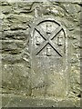
Old Boundary Marker in College Lane, Plymouth
Municipal Boundary Marker set low down in a stone wall by a lamp post on the west side of College Lane, Plymouth. Inscribed J. SHELLY / 1893 for John Shelley (sic), mayor.
Milestone Society National ID: DV_PCBS30pb
Image: © T Jenkinson
Taken: 31 May 2012
0.13 miles