IMAGES TAKEN NEAR TO
Dale Road, PLYMOUTH, PL4 6PE
Introduction
This page details the photographs taken nearby to Dale Road, PL4 6PE by members of the Geograph project.
The Geograph project started in 2005 with the aim of publishing, organising and preserving representative images for every square kilometre of Great Britain, Ireland and the Isle of Man.

There are currently over 7.5m images from over14,400 individuals and you can help contribute to the project by visiting https://www.geograph.org.uk
Image Map
Images are licensed for reuse under creativecommons.org/licenses/by-sa/2.0
Notes
- Clicking on the map will re-center to the selected point.
- The higher the marker number, the further away the image location is from the centre of the postcode.
Image Listing (628 Images Found)
Images are licensed for reuse under creativecommons.org/licenses/by-sa/2.0
Image
Details
Distance
6
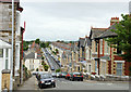
Maple Grove, Mutley
Terraced housing to the north of the railway.
Image: © Pierre Terre
Taken: 20 Jun 2009
0.07 miles

8
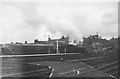
East end of North Road station
A steam engine pilots Warship no D601 Ark Royal away from Plymouth towards Newton Abbot
Image: © John Firth
Taken: Unknown
0.08 miles
10
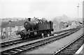
Shunting locomotive, Plymouth North Road Station, 1963
No. 4555, one of the small prairie class. This is an earlier example with straight top tanks, in contrast to http://www.geograph.org.uk/photo/6429096 of the same class.
Image: © Alan Murray-Rust
Taken: Unknown
0.09 miles