IMAGES TAKEN NEAR TO
Mutley Plain, PLYMOUTH, PL4 6JG
Introduction
This page details the photographs taken nearby to Mutley Plain, PL4 6JG by members of the Geograph project.
The Geograph project started in 2005 with the aim of publishing, organising and preserving representative images for every square kilometre of Great Britain, Ireland and the Isle of Man.

There are currently over 7.5m images from over14,400 individuals and you can help contribute to the project by visiting https://www.geograph.org.uk
Image Map
Images are licensed for reuse under creativecommons.org/licenses/by-sa/2.0
Notes
- Clicking on the map will re-center to the selected point.
- The higher the marker number, the further away the image location is from the centre of the postcode.
Image Listing (353 Images Found)
Images are licensed for reuse under creativecommons.org/licenses/by-sa/2.0
Image
Details
Distance
4
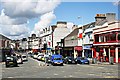
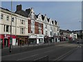
Mutley Plain, southern end
Mutley Plain has been a transport route for a long time. The plain is a flat col area of between what used to be two tidal creeks to the east and west which made this the only dry route into Plymouth until the creeks were filled in. Drake's leat, which fed water into Plymouth from Dartmoor used to run along the west side of the street. In the Civil war this was the 'no mans land' between the Parliamentarian defenders on the high ground behind me and the Royalist besiegers on the high ground at the far end of the plain, although no direct assault was ever attempted across this land. The huge expansion of Plymouth in the 19th century brought the street largely as we see it today. It quickly became a retail centre for people living in the adjoining terraces although its heyday as a shopping centre was probably during and immediately following the Second World War when the main shopping centres of Plymouth and Devonport were almost completely destroyed by bombing. From the 1950's to the 1970's Mutley Plain slowly declined as a shopping centre with retail stores being slowly replaced by Estate Agents. The huge boom in student numbers in Plymouth in the 1990's, many of whom live in bedsits in the area has led to the opening of more bars, and fast food establishments and revived food-based retailing somewhat. The buildings in the right foreground are a good example of the character of this street now consisting of three bars, a coffee bar, a slot machine arcade and an estate agent. The way things are going I would expect the estate agent to be replaced by another bar sometime soon, which is progress of sorts. I have used the more North American word 'bar' here to describe these new drinking establishments because they are really not traditional pubs at all.
Image: © Tony Atkin
Taken: 28 May 2007
0.02 miles
5
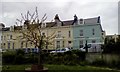
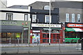
Moor View Terrace overlooking Moorview Park
The small, shallow park is in the foreground
Image: © David Smith
Taken: 7 May 2019
0.03 miles
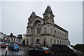
9
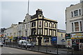
Fortescue Arms
An excellent pub, local CAMRA pub of the year many times.
Image: © N Chadwick
Taken: 25 Oct 2015
0.03 miles