IMAGES TAKEN NEAR TO
Caprera Place, PLYMOUTH, PL4 6AG
Introduction
This page details the photographs taken nearby to Caprera Place, PL4 6AG by members of the Geograph project.
The Geograph project started in 2005 with the aim of publishing, organising and preserving representative images for every square kilometre of Great Britain, Ireland and the Isle of Man.

There are currently over 7.5m images from over14,400 individuals and you can help contribute to the project by visiting https://www.geograph.org.uk
Image Map
Images are licensed for reuse under creativecommons.org/licenses/by-sa/2.0
Notes
- Clicking on the map will re-center to the selected point.
- The higher the marker number, the further away the image location is from the centre of the postcode.
Image Listing (978 Images Found)
Images are licensed for reuse under creativecommons.org/licenses/by-sa/2.0
Image
Details
Distance
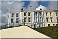
6
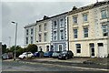
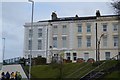
North Road East, Plymouth
Judging by the provision for parking, and the number of cars, these houses are in multiple occupation.
Photo number 7578316
Image: © Robin Stott
Taken: 30 Jun 2023
0.02 miles
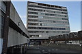
7
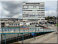
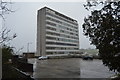
Office block by the station, from the footbridge
Part of the footbridge can also be seen.
Image: © Ruth Sharville
Taken: 25 Jul 2009
0.02 miles

10
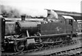
A GW 'Small Prairie 2-6-2T at Plymouth North Road Station
Collett '4575' No. 5569 (built 1/29) stands in the rain at Plymouth's main station, probably on a Tavistock and Launceston train.
Image: © Ben Brooksbank
Taken: 25 Jul 1958
0.02 miles